
Tensar+ designprogramvare
Tensar+ er en gratis, skybasert geoteknisk designprogramvare som lar ingeniører, entreprenører og eiere designe med geonett i en rekke applikasjoner. Den nylig forbedrede designløsningen har en forenklet brukeropplevelse med alle funksjonene ingeniører har kommet til å forvente og er avhengige av med Tensar geoteknisk programvare.
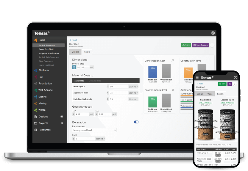
Bruk plattformen til å designe prosjektet ditt, tilpasse spesifikasjonene og se kostnadsbesparelsene i sanntid.
Tensar+ geotekniske designprogramvareplattform lar deg:
- Design og evaluer prosjektspesifikasjoner
- Sammenlign alternative materialer og prosjektforhold
- Se kostnadene og tidsbesparelsene i sanntid når du endrer parametere
- Analyser bærekraften til prosjektene dine
Velg mellom en rekke programvaremoduler for konstruksjon og geoteknisk design
Tensar+ har en rekke moduler tilgjengelig for å støtte dine bygge- og geotekniske designprosjekter. Oppdag våre nåværende og kommende designmoduler nedenfor.
Programvare for veibygging
Med veidesign- og konstruksjonsmodulen i vår geotekniske programvareplattform kan designingeniører visualisere, forberede og forstå parametrene og kravene til prosjekter før bygging, inkludert spesifikasjonene for stabiliserte lag. Ved å mekanisk stabilisere de ubundne lagene i et vegdekkedesign, kan du maksimere kostnadene og karbonutslippsbesparelsene som kan oppnås gjennom reduksjon av dekkets tykkelse i konstruksjonen. Tensars tilnærming bruker den mest oppdaterte kunnskapen om hvordan et geonett fungerer når det inkluderes i en vei som er utsatt for dynamisk trafikkbelastning.
Midlertidig fungerer programvare
Midlertidige arbeidsplattformer er en utrolig viktig del av mange byggeprosjekter, og gir bygningsarbeidere og ingeniører stabile og trygge arbeidsområder. Ved å bruke den midlertidige arbeidsdesignmodulen i Tensar+ kan du bruke Tensars nyeste applikasjonsteknologi for mekanisk stabiliserte arbeidsplattformer og tilby trygge plattformer som sparer prosjektkostnader og øker miljømessige legitimasjoner. Tensars T-Value designtilnærming er et troverdig alternativ til veiledningen som tilbys i BR470 med en dokumentert merittliste og er implementert i Tensar+ programvare.
Underlag stabiliseringsprogramvare
Arbeid på svak eller variabel grunn byr vanligvis på betydelige konstruksjonsutfordringer, derfor er det viktig å designe et sikkert mekanisk stabilisert lag før konstruksjon. Ved å bruke undergrunnsstabiliseringsmodulen i vår geotekniske programvareløsning, kan mekanisk stabiliserte lag designes før konstruksjon, noe som beskytter undergrunnen ytterligere og forbedrer bæreevnen. Tensars designmetoder og løsninger for undergrunnsstabilisering er allment akseptert og brukt over hele verden.
Geoteknisk designprogramvare på desktop, mobil og nettbrett
Vår geotekniske programvare er fullstendig skybasert og gratis å bruke mens du er på farten – få tilgang til Tensar+ hvor som helst, når som helst og hvor som helst. Du trenger ikke ekstra harddiskplass på enheten din, eller noen spesielle krav for å komme i gang med designene dine. Og hvis teamet ditt trenger å designe ute i felten, laster du bare ned appen.
Hvordan komme i gang med Tensar+ programvare for geoteknisk design
Det er raskt, enkelt og gratis å komme i gang med Tensar+. Bare besøk Tensar+-nettstedet og registrer deg for en konto, og start deretter et nytt design eller prosjekt direkte fra hjemmesiden.